Teiki Mathieu Baillan surfing a self-made Alaya surfboard in Macaroni, Mentawaï, Indonesia. Photo by C. Naslain, 2009.
Enjoy and contribute!
| Find the best surf spots |
|
|
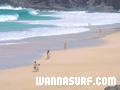
![]() El Risco
El Risco
Canary, Lanzarote
This is an interactive map! Use controls to pan and zoom this map.
|
Datum: WGS84 [ Help ] |
Latitude: 29° 12.466' N |
User rating (11)
- Add to my surfed spots
- Comments (11)
- sessions (0)
- trips (0)
- Photos (1)
- Videos (0)
- Share
- Favourite
-
Your favourites and future surf spot lists
Access
|
This is one of the wildest beaches on the island due to its difficult access - by boat from Orzola or by coming down the cliffs at Famara. DistanceTake a car WalkLong walk (>30 mn) Easy to find?OK Public access? Special access4x4 |
Surf Spot Characteristics
Surf Spot Quality
Wave qualityNormal
ExperienceAll surfers
FrequencyRegular
Wave
TypeBeach-break
DirectionRight and left
BottomSandy
PowerFun
Normal lengthNormal (50 to 150m)
Good day lengthLong (150 to 300 m)
Tide, Swell and Wind
Good swell direction
Good wind direction
Swell sizeStarts working at and holds up to
Best tide position
Best tide movement
More details
Week crowdEmpty
Week-end crowdEmpty
Dangers
Additional Information
park the car 2 km down the hill from mirador del rio close to the village. take enough water for the whole day there is nothing....
Atmosphere
General
Author: frank herrmann Contributors (2)
 Comments
By anonymous , 06-11-2005
el risco is real - it is not antoher mythos of el risco...the spot exists and sometimes is works very wellall dumbs schouldt check it from mirador del rio!!!and the locals from famara are more handsome than any other local or like my mother..
By Un godo de mierda.... , 03-07-2005
- Lo que sois es unos hijos del a granputa cagones, cada vez que se pone de más de metroymedio tengo que buscar un compinche para no entrar solo.Vete a tomar por culo PELIGROSO...(hay que joderse) Seguro q te encanta el "regeton"y los coches tunin eh? payaso
Errors, Feedback
You can edit this page to correct errors or add new information. If you have any problems regarding this page, Send us feedback.
Advertise
On the Go!
Wannasurf.com on your mobile
![]()
RSS All the RSS feeds of Wannasurf.com
Newsletter All news by email
By Jelle , 31-03-2008
location - Hi, I'm trying to find out where all surfspots are at lanzarote with google earth/maps, but I can't really figure out this spot. I think it is over here (http://maps.google.nl/maps?f=q&hl=nl&geocode=&q=Tenerife,+Spain&ie=UTF8&ll=29.195665,-13.507433&spn=0.029633,0.067635&t=h&z=15), but is this correct? And exactly which part of the coastline that I pointed out, as that part of the coast visible in the link I posted is approx. 3 km long.