Teiki Mathieu Baillan surfing a self-made Alaya surfboard in Macaroni, Mentawaï, Indonesia. Photo by C. Naslain, 2009.
Enjoy and contribute!
| Find the best surf spots |
|
|
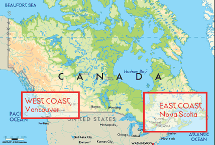
 Canada
North America
Geographic coordinates:60 00 N, 95 00 W
Coastline:202,080 km
Climate:varies from temperate in south to subarctic and arctic in north
Terrain: mostly plains with mountains in west and lowlands in southeast
Natural hazards: continuous permafrost in north is a serious obstacle to development; cyclonic storms form east of the Rocky Mountains, a result of the mixing of air masses from the Arctic, Pacific, and North American interior, and produce most of the country's rain and snow east of the mountains
Currency:Canadian dollar (CAD)
Currency code:CAD
Location: Northern North America, bordering the North Atlantic Ocean on the east, North Pacific Ocean on the west, and the Arctic Ocean on the north, north of the conterminous US
Geographic coordinates: 60° 0' N, 95° 0' W
Coastline km: 202,080 km km
Climate: varies from temperate in south to subarctic and arctic in north
Terrain: mostly plains with mountains in west and lowlands in southeast
Elevation: lowest point: Atlantic Ocean 0 m
highest point: Mount Logan 5,959 m
Natural hazards: continuous permafrost in north is a serious obstacle to development; cyclonic storms form east of the Rocky Mountains, a result of the mixing of air masses from the Arctic, Pacific, and North American interior, and produce most of the country's rain and snow east of the mountains
Currency: Canadian dollar (CAD)
Population: 33,098,932 (July 2006 est.)
Languages: English (official) 59.3%, French (official) 23.2%, other 17.5%
Capital: Ottawa
Divisions: 10 provinces and 3 territories*; Alberta, British Columbia, Manitoba, New Brunswick, Newfoundland and Labrador, Northwest Territories*, Nova Scotia, Nunavut*, Ontario, Prince Edward Island, Quebec, Saskatchewan, Yukon Territory*
More details
| Jan/Feb | Mar/Apr | May/Jun | Jul/Aug | Sep/Oct | Nov/Dec | |
|---|---|---|---|---|---|---|
| Best Surfing Season | ||||||
| Typical Swell Size | ||||||
| Surf Equipment | ||||||
| Water temp. | ||||||
| Air temp. | ||||||
| Climate | ||||||
Seasonal swell & wind variations
Wanna add some info about Canada? Let us know...
This is an interactive map! Use controls to pan and zoom this map.
- Favourite
-
Your favourites and future surf spot lists
Your favorite zone isn't listed ? Add a zone
Zones
| Zones (3) | Surf Spots | Sub zones |
|---|---|---|
| Great Lakes | 17 | 0 |
| West Coast | 30 | 0 |
| East Coast | 39 | 0 |
Surf Spots
| Surf Spots (2) | Quality | Direction | Type | Frequ | Experience | ||
|---|---|---|---|---|---|---|---|
| Bates Island, Ottawa River | 3 / 1 | Left | Rivermouth | 
|
Experienced surfers | ||
| Chambly Rapids | 1 / - | Right and left | Rivermouth | 
|
Experienced surfers |
 Photos
Cow bay - moose rocks |
Cow bay - moose rocks |

Ingonish beach |

Ingonish beach |
Comments
By NthWpgBasin , 27-01-2012
There Can Be waves up to about 9 feet on lake winnipeg. - The only great surfing spot is only accessable by jetski so only about a dozen people know about it. Its in the north basin where it goes from 20 foot water to about 5 foot water because of an underwater cliff.
By Dan , 13-07-2008
Up North? - Had a mate from Yellowknife that swears the lake fetch barrels in... anybody ever been?
By Neuf , 13-07-2007
No surf in Winnipeg - There is no surf in Winnipeg - trust me I live here! Great City and beaches but no waves.
Errors, Feedback
If you want to add new information or you have found errors on this country, Send us feedback.
Advertise
On the Go!
Wannasurf.com on your mobile
![]()
RSS All the RSS feeds of Wannasurf.com
Newsletter All news by email